
The Worlds Toughest Hurricane Screen
Tried | True | Tested.
PROTECTION THAT PERFORM
No Blowouts. No Rewraps. No Compromise....
MaxForce Hurricane Screens are the result of years of real-world testing, research, and engineering refinement. Built to withstand the harshest conditions without sacrificing aesthetics, they offer maximum protection for your patio or lanai with hurricane-rated performance.
Tested, Trusted, Proven, and Never compromised—these screens are built for the long haul:
Your Vision Deserves
A Partner
Who Listens...
Your Vision Deserves
A Partner
Who Listens...
MAXFORCE & FL OUTDOOR
READY FOR LIFE'S STORMS
MAXFORCE & FL OUTDOOR
READY FOR LIFE'S STORMS
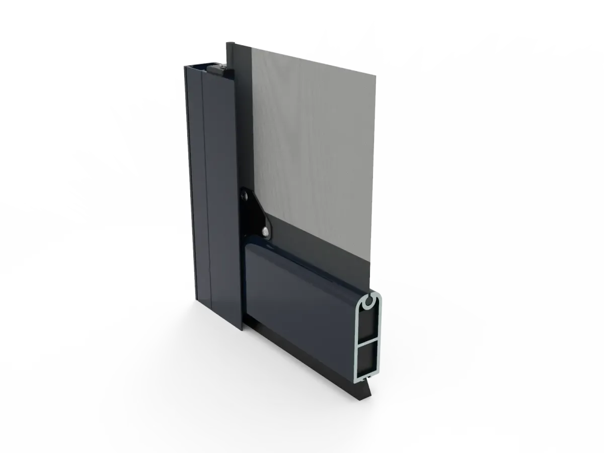
MAXFORCE HURRICANE SCREEN SYSTEM
A Certified, Tested System...
The MaxForce Hurricane Screen System meet or exceeds Miami-Dade and Florida Building Code requirements—the toughest hurricane codes on earth—for roll-down hurricane screens. Rated for the 185 MPH wind zone, and with real-world and certified testing. With spans of up to 24 feet, they exceed performance criteria for all local and International Building Codes.
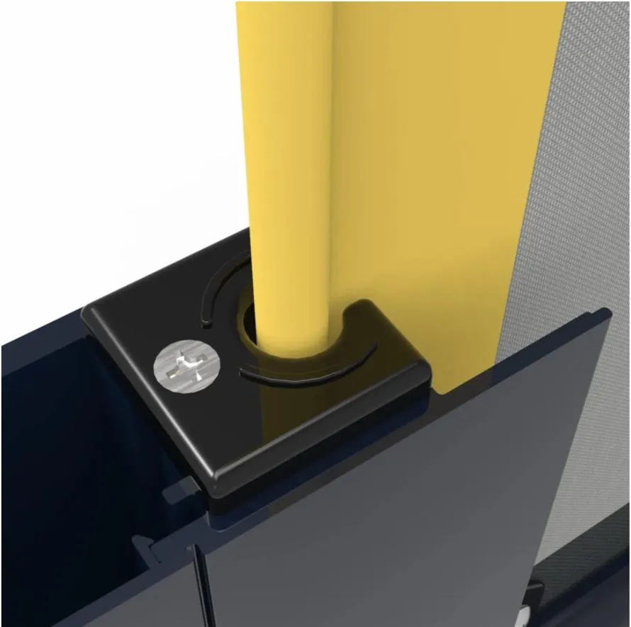
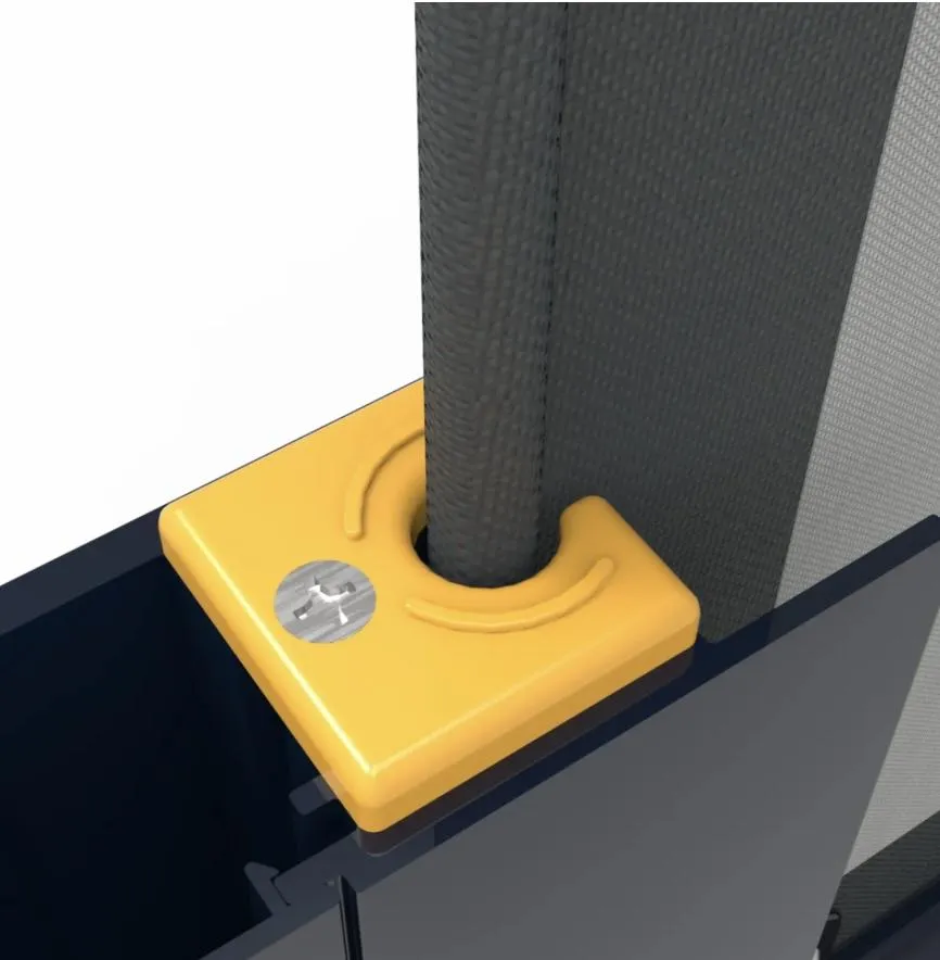
MAXFORCE IS THERE
When You Need It The Most

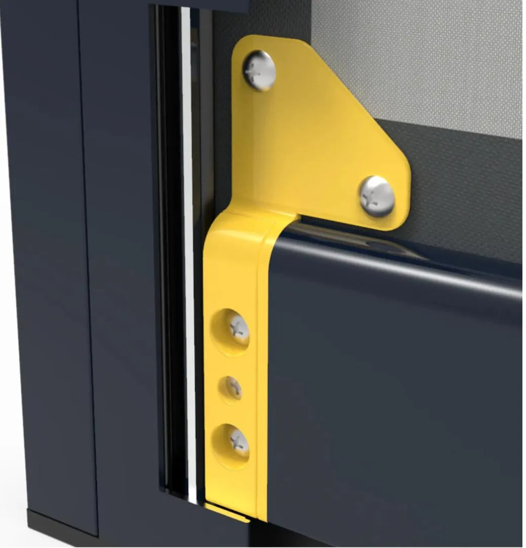
Secure Track
MaxForce Fix Hurricane Track holds firm under extreme loads

Max Corrosion Protection
Powder Coated Aluminum Protects your investment from exposure and corrosion.

Heavy-Duty Design
Our screens are designed to withstand the extreme. High wind, Rain, or Shine, Dust Dirt, Dander, it does not matter. MaxForce covers it all
MAXFORCE IS THERE
When You Need It The Most
Secure Track
MaxForce Fix Hurricane Track holds firm under extreme loads
Max Corrosion Protection
Powder Coated Aluminum Protects your investment from exposure and corrosion.
Heavy-Duty Design
Our screens are designed to withstand the extreme. High wind, Rain, or Shine, Dust Dirt, Dander, it does not matter. MaxForce covers it all
Your Vision Deserves
A Partner
Who Cares...
Your Vision Deserves
A Partner
Who Cares...
THE MAXFORCE HURRICANE SCREEN DIFFERENCE
MaxForce Hurricane Screen
MaxForce Hurricane Screens, powered by our patented MaxForce system, meet the toughest standards—including HVHZ certification in Miami-Dade and Broward. They last longer, resist more, and do more than any screen on the market—proven protection without compromise.
.
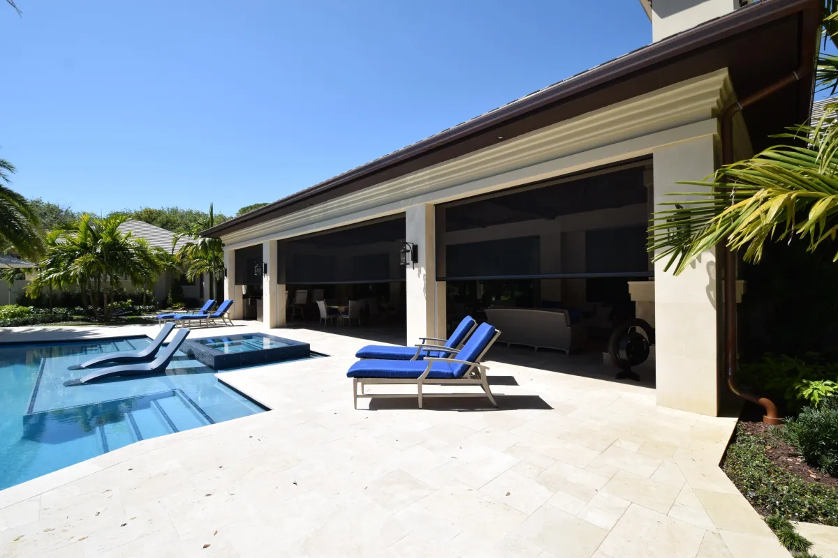
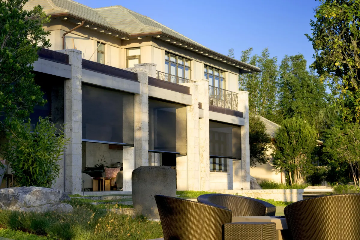
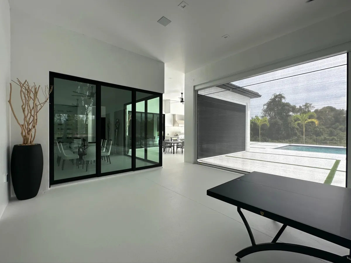
MaxForce Hurricane Screens —Delivers 365 days of perfect protection, rain or shine, on your patio and lanai. With the push of a button or a tap on the mobile app, your patio is storm-ready— furniture and openings fully protected in seconds.
.
MaxForce Hurricane Screens fabric blocks up to 95% of the sun’s damaging UV-rays while shielding against wind, rain, insects, dust, and debris. It also helps reduce heat and lower energy costs by limiting solar exposure—comfort and protection in one smart solution.
.
Like all Fenetex products, our MaxForce Hurricane Screens are highly customizable and built to order—made to fit your exact openings. No guesswork, no compromises—just precision-fit protection tailored to your space.
.
Pair our retractable MaxForce Hurricane Screens with other Fenetex screens for customized and independent solutions. Each screen operates independently, giving you the protection you want when you need it.
MaxForce Hurricane Screens offer built-in privacy without blocking your view. Like a two-way mirror, you can see out—but neighbors and passersby cannot see in. It provides the perfect blend of openness and seclusion, day or night.
THE MAXFORCE HURRICANE SCREEN DIFFERENCE
MaxForce Hurricane Screen
MaxForce Hurricane Screens, powered by our patented MaxForce system, meet the toughest standards—including HVHZ certification in Miami-Dade and Broward. They last longer, resist more, and do more than any screen on the market—proven protection without compromise.
.
MaxForce Hurricane Screens —Delivers 365 days of perfect protection, rain or shine, on your patio and lanai. With the push of a button or a tap on the mobile app, your patio is storm-ready— furniture and openings fully protected in seconds.
.
MaxForce Hurricane Screens fabric blocks up to 95% of the sun’s damaging UV-rays while shielding against wind, rain, insects, dust, and debris. It also helps reduce heat and lower energy costs by limiting solar exposure—comfort and protection in one smart solution.
.
Like all Fenetex products, our MaxForce Hurricane Screens are highly customizable and built to order—made to fit your exact openings. No guesswork, no compromises—just precision-fit protection tailored to your space.
.
Pair our retractable MaxForce Hurricane Screens with other Fenetex screens for customized and independent solutions. Each screen operates independently, giving you the protection you want when you need it.
MaxForce Hurricane Screens offer built-in privacy without blocking your view. Like a two-way mirror, you can see out—but neighbors and passersby cannot see in. It provides the perfect blend of openness and seclusion, day or night.

ADJUSTABLE ABILITY: MANUAL
Fixed Track
LOCKS TIGHT
Ultimate Strength

RATED FOR
185mph Wind Zone
APPLICATION
Residential & Commercial
ADJUSTABLE ABILITY: MANUAL
Fixed Track
LOCKS TIGHT
Ultimate Strength
RATED FOR
185mph Wind Zone
APPLICATION
Residential & Commercial
IT'S AS EASY AS 1, 2, 3
Customize Your Screen
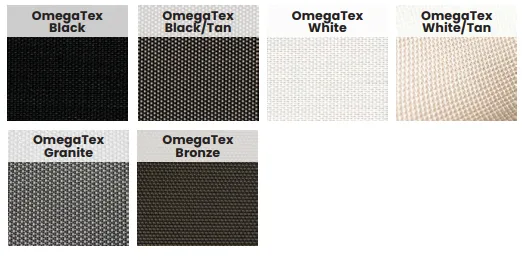
STEP ONE:
Choose Your Screen Color...
Backed by Twitchell’s OmegaTex fabric, our hurricane screens are engineered with ballistic-grade and enhanced fibers for maximum strength and durability. These fabrics aren’t just tough—they’re also UV-protected for long-lasting performance and crafted with aesthetics in mind. Choose from six elegant colors designed to complement the architecture of your home.
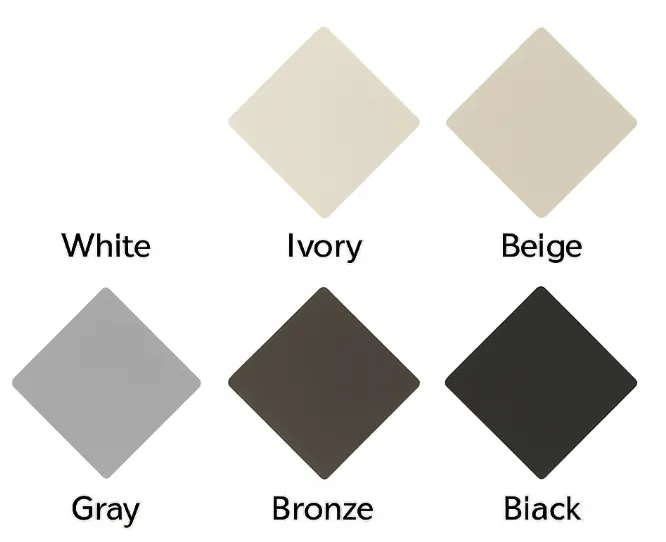
STEP TWO:
Choose Your Frame Color...
Choosing the right screen color is simple with . Our standard color selections are designed to blend seamlessly with your architecture and framework, offering a clean, cohesive look. For unique designs, custom powder coating is available to match any project. All finishes are marine-grade and infused with UV ray inhibitors—built to endure the elements and maintain their beauty for years to come.
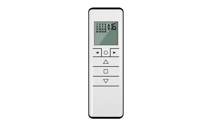
STEP THREE:
3. Choose Your Control
Selecting your preferred control method is effortless with MaxForce Hurricane Screens. Whether you choose handheld remotes, mobile apps, or smart home integration, our systems are designed to fit your lifestyle. No need to settle—just integrate and enjoy continuous, seamless operation 24/7. It's control on your terms, exactly when and where you need it.
IT'S AS EASY AS 1, 2, 3
Customize Your Screen
STEP ONE:
Choose Your Screen Color...
Backed by Twitchell’s OmegaTex fabric, our hurricane screens are engineered with ballistic-grade and enhanced fibers for maximum strength and durability. These fabrics aren’t just tough—they’re also UV-protected for long-lasting performance and crafted with aesthetics in mind. Choose from six elegant colors designed to complement the architecture of your home.
STEP TWO:
Choose Your Frame Color...
Choosing the right screen color is simple with . Our standard color selections are designed to blend seamlessly with your architecture and framework, offering a clean, cohesive look. For unique designs, custom powder coating is available to match any project. All finishes are marine-grade and infused with UV ray inhibitors—built to endure the elements and maintain their beauty for years to come.
STEP THREE:
3. Choose Your Control
Selecting your preferred control method is effortless with MaxForce Hurricane Screens. Whether you choose handheld remotes, mobile apps, or smart home integration, our systems are designed to fit your lifestyle. No need to settle—just integrate and enjoy continuous, seamless operation 24/7. It's control on your terms, exactly when and where you need it.
Your Vision Deserves
A Partner
Who Delivers...
MAXFORCE SEAMLESS
Smart Home Integration
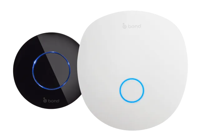
BLEND SEAMLESSLY
Take Control - Smart Hub.
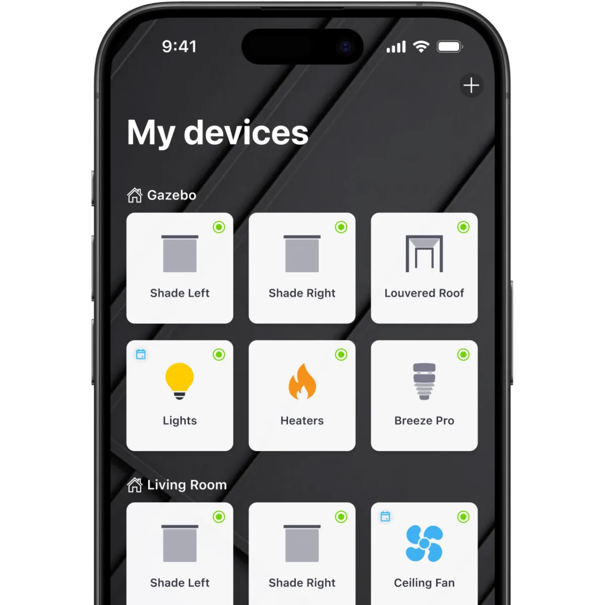
With the Bond Bridge Pro, managing your MaxForce Hurricane Screens is seamless and smart. This powerful integration allows you to open or close your screens from anywhere using your smartphone, voice assistant, or home automation system. Whether you're at home, at work, or away on vacation, control is always at your fingertips.
COMPATIBLE INTEGRATION


VOICE ACTIVATION ASSISTANTS


SMART MOTOR TECHNOLOGIES


Your Vision Deserves
A Partner
Who Delivers...
MAXFORCE SEAMLESS
Smart Home Integration
BLEND SEAMLESSLY
Take Control - Smart Hub.
With the Bond Bridge Pro, managing your MaxForce Hurricane Screens is seamless and smart. This powerful integration allows you to open or close your screens from anywhere using your smartphone, voice assistant, or home automation system. Whether you're at home, at work, or away on vacation, control is always at your fingertips.
COMPATIBLE INTEGRATION
VOICE ACTIVATION ASSISTANTS
SMART MOTOR TECHNOLOGIES
Integrity Matters
Where It's Made Matters
Integrity Matters
Where It's Made Matters
MAXFORCE PROVEN PROTECT
Engineered For Excellence
For nearly two decades MaxForce Hurricane Screens has manufactured hurricane screens to meet the most demanding building code, the High Velocity Hurricane Zone of Miami-Dade. The MaxForce track is our newest version of the fixed track we have used with great success for high wind applications all over the globe.
The benefits of a fixed track are unmatched strength - this is important when designing a screen system for hurricanes. When you want the strongest system available, and a proven veteran of many hurricanes, the MaxForce Hurricane Track is your best choice.
No blowouts. No rewraps. No frustration.
MaxForce is the only retractable screen system on the market designed to stay locked in the track—even in high winds. Smart motor senses resistance and adjusts seamlessly, allowing self-correction when the screen encounters an obstacle: Fewer snags, fewer jams, and fewer costly service calls.
No Zipper. No Cable. Just Simple Deployment
MaxForce Hurricane Screens pioneered Keder-edge technology in motorized screens, delivering unmatched durability and simplicity. Borrowed from sailboat rigging, this system eliminates zippers, cables, and exposed hardware—ensuring smooth, reliable operation every time.
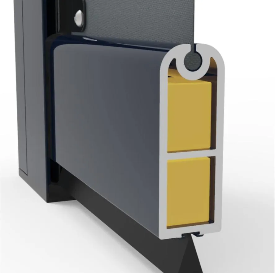
Heavy Duty
The MaxForce weight bar is engineered for strength—and built to hold its ground. Pound for pound, it’s the heaviest and most robust weight bar in the industry. This ensures proper screen tension, flawless deployment, and maximum stability in high wind zones. —limited flex, no failure.
Reinforced Corners
MaxForce’s heavy-duty weight bar isn’t just strong. It’s smart. Reinforced corners and integrated tie-ins create a unified structure that acts like a solid wall of protection when deployed. Made from high-strength nylon, this bar absorbs impacts while maintaining structural integrity.
No blowouts. No rewraps. No frustration.
MaxForce is the only retractable screen system on the market designed to stay locked in the track—even in high winds. Smart motor senses resistance and adjusts seamlessly, allowing self-correction when the screen encounters an obstacle: Fewer snags, fewer jams, and fewer costly service calls.
No Zipper. No Cable. Just Simple Deployment
MaxForce Hurricane Screens pioneered Keder-edge technology in motorized screens, delivering unmatched durability and simplicity. Borrowed from sailboat rigging, this system eliminates zippers, cables, and exposed hardware—ensuring smooth, reliable operation every time.
Heavy Duty
The MaxForce weight bar is engineered for strength—and built to hold its ground. Pound for pound, it’s the heaviest and most robust weight bar in the industry. This ensures proper screen tension, flawless deployment, and maximum stability in high wind zones. —limited flex, no failure.
Reinforced Corners
MaxForce’s heavy-duty weight bar isn’t just strong. It’s smart. Reinforced corners and integrated tie-ins create a unified structure that acts like a solid wall of protection when deployed. Made from high-strength nylon, this bar absorbs impacts while maintaining structural integrity.
Your Vision Deserves
A Partner,
Not Just A Vendor
AMERICAN INGENUITY
Made in the USA.
Proudly Made in the USA—every MaxForce Hurricane Screen is built with American strength, precision, and pride. From the smallest components to the final assembly, our materials are sourced and manufactured right here in the United States. No outsourcing. No compromises. Just hardworking Americans protecting American homes with the toughest screen system on the market.
CONSISTENCY.
Quality Made. Professional Installation....
At FL OUTDOOR, quality isn’t a buzzword—it’s a promise. Every MaxForce Hurricane Screens system we install is a product of precision engineering and world-class American manufacturing, built to perform under pressure and look flawless doing it.
We are highly trained professionals who treat your home like their own. From laser-accurate measurements to clean, detail-focused installations, we don’t cut corners—we define them.
See What Our Customers Are Saying About Us
See What Our Customers Are Saying About Us
BEYOND
The Here & Now
BEYOND
The Here & Now
BEYOND
The Here & Now
BEYOND
The Here & Now
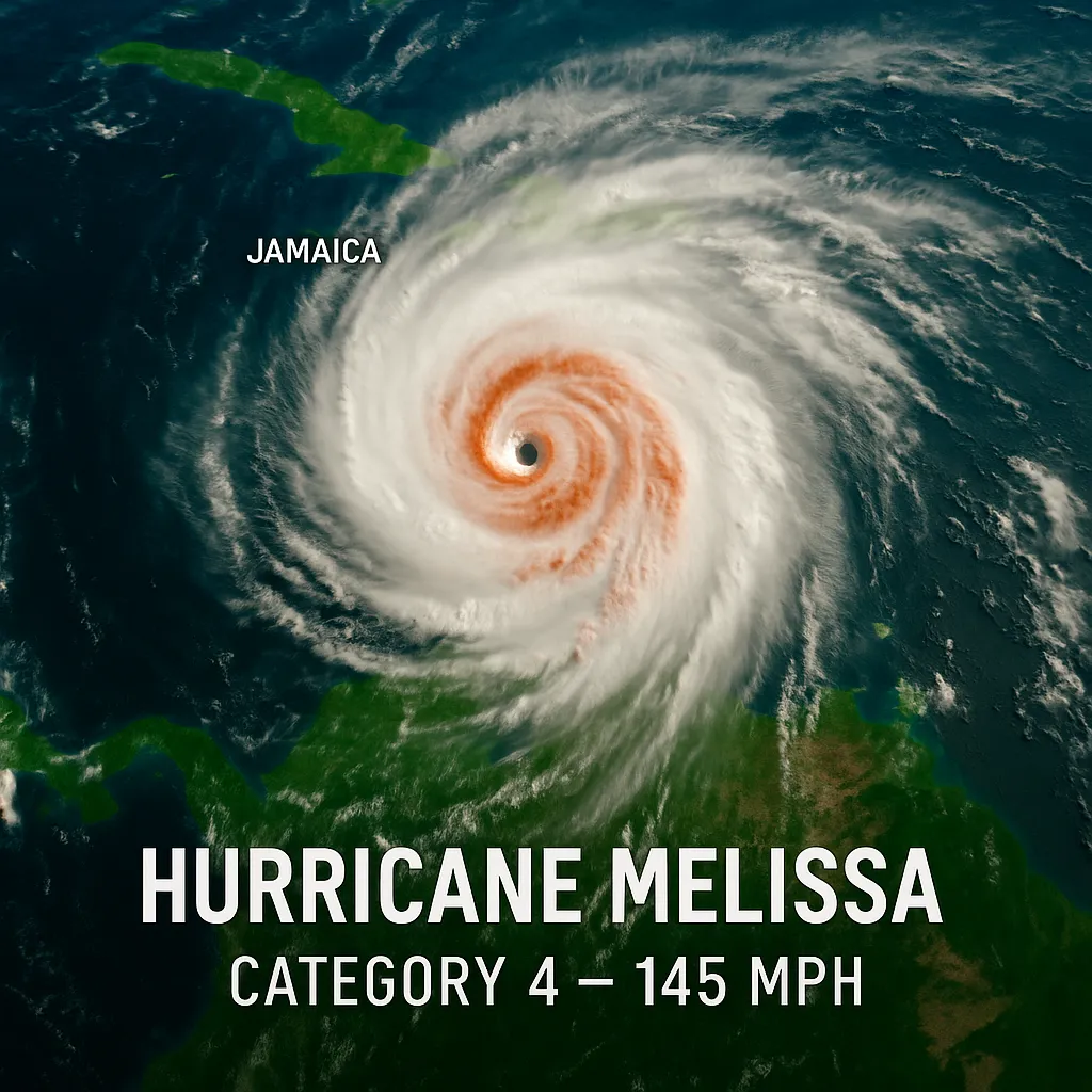
Hurricane Melissa and Why October Is Florida's Most Dangerous Month
Why October Is Florida's Most Dangerous Month
It's late October in Florida.
The Halloween decorations are up. Kids are settled into their school routines. And for most homeowners across the Sunshine State, hurricane season feels like something that already happened—a worry from August and September that's now safely behind us.
Then your phone buzzes with an alert.
Hurricane Melissa has exploded into a Category 4 monster. Winds are screaming at 145 mph across the Caribbean. Jamaica is bracing for what could be the strongest hurricane in its recorded history. The storm's eye—tight, organized, menacing—is visible from space as it grinds westward at just 5 mph.
Right now, Melissa isn't headed for Florida. But that's not really the point, is it?
The point is this: it's late October, and a catastrophic hurricane is churning in our backyard.
The Month That Catches Everyone Off Guard
Ask most Floridians when hurricane season peaks, and they'll tell you August or September. They're not wrong—those months see the most activity. But here's what the statistics actually show: more hurricanes have impacted South Florida in October than any other month.
Read that again.
Since 1851, twenty-six October hurricanes have passed within 100 nautical miles of Miami. Between 1851 and 2019, eleven major hurricanes—Category 3 or stronger—have slammed into Florida during October alone.
The names tell their own story. Michael. Wilma. Opal. King. Each one carved its legacy into Florida's coastline and into the memories of the people who lived through them.
Hurricane Michael obliterated Mexico Beach in 2018. Category 5 winds. October 10. One of only four storms of that magnitude to ever strike the United States.
Two years ago, Hurricane Milton reached sustained winds of 180 mph on October 7 before hammering Siesta Key as a major Category 3.
These aren't flukes. This is a pattern. And the pattern is accelerating.
Why October Hurricanes Play By Different Rules
Think about a typical September hurricane. It forms off the coast of Africa. Forecasters track it for days, sometimes weeks, as it crawls across the Atlantic. By the time it reaches the Caribbean, you've had plenty of warning. Plenty of time. Evacuations get ordered. Shutters go up. People prepare.
October hurricanes don't give you that courtesy.
As fall arrives, the atmospheric dynamics shift. Those long-tracking African systems fade away. Instead, storms fire up in the western Caribbean Sea and the southern Gulf of Mexico. They form close. Dangerously close.
The distance from the western Caribbean to the Florida Keys? Less than 400 miles.
At a typical forward speed of 15 mph, that gives you barely 24 hours of warning. And if the storm crawls like Melissa is doing right now—5 mph over Jamaica—it creates a different nightmare. One that parks over you. One that drowns everything beneath it.
Evan Thompson runs Jamaica's Meteorological Service. Here's what he said about Melissa: "It's going to sit there pouring water while it's barely moving. It's going to cause significant, widespread, catastrophic, life-threatening floods."
That's not a forecast for some distant island. That's a preview of what happens when an October storm decides Florida looks inviting.
And there's more.
October ocean temperatures sit at their warmest levels of the year. Air cools down in autumn. Water doesn't—not yet. That lag creates what meteorologists call "available heat content." It's fuel. Pure energy sitting there waiting to be tapped.
Watch what happens when a storm finds that fuel.
Three of the four Atlantic hurricanes in 2025 underwent extreme rapid intensification. Erin. Gabrielle. Humberto. Now Melissa has joined the club, doubling its wind speed in under 24 hours.
This isn't unusual anymore. It's becoming the norm. Scientists have traced the connection directly to warming ocean temperatures caused by fossil fuel pollution. Rapid intensification events—once rare—are now something forecasters expect.
The Problem With Less Time and More Uncertainty
Diane Thompson sells herbs in Kingston, Jamaica. When Reuters asked her about Melissa approaching, she said something that gets right to the heart of October hurricanes: "When it's moving slow, it's the worst because no one knows what's next."
She's right about the uncertainty. But there's also the time problem.
When a September hurricane forms off Africa, you have time to watch it develop. Time to see multiple forecast models. Time to debate evacuation. Time to book a hotel three states away. Time to board up properly. Time to move vehicles to higher ground.
When an October hurricane spins up in the western Caribbean on a Friday, you're making life-or-death decisions by Sunday morning.
And if the storm stalls—like Melissa is doing right now—the forecast cone doesn't shrink. It grows. Bigger. Wider. More uncertain with every passing hour.
The National Hurricane Center doesn't use dramatic language often. They're scientists. They stick to the facts. But in their forecast discussion for Jamaica, they warned of "extensive infrastructural damage, long-duration power and communication outages, and potentially prolonged isolation of communities."
That language isn't reserved for islands. It applies anywhere these storms decide to go.
When the Calendar Lies to You
Atlantic hurricane season officially ends November 30.
Hurricanes didn't get the memo.
Hurricane Kate hit the Florida panhandle on November 22, 1985—a Category 2 storm arriving when most people had already packed away their emergency kits. In 2022, Hurricane Nicole made landfall in early November, setting the record for the latest hurricane to strike Florida's east coast.
Last year saw five named storms develop in October. Hurricane Milton became 2024's most intense storm with those 180 mph winds—in October.
But if you want to understand just how deadly late-season hurricanes can be, look at the history books.
The Great Hurricane of 1780 killed nearly 20,000 people across the Caribbean. October.
Hurricane Mitch stalled over Central America in 1998 and killed close to 20,000 more. October.
Slow-moving storms. Torrential rainfall. Catastrophic flooding. That's October's signature.
The Dangerous Comfort of September's End
By late October, you're tired of thinking about hurricanes. Five months of watching forecasts, tracking storms, debating whether to fill sandbags—it wears you down. Psychologists call it "hurricane fatigue." And it's dangerous.
You made it through September. The peak is behind you. The worst is over.
Except it's not.
Hurricane Wilma formed on October 17, 2005. Within 24 hours, it went from a 70 mph tropical storm to a 170 mph Category 5 hurricane. Peak winds hit 185 mph. The barometric pressure dropped to 882 mb—the lowest ever recorded in the Atlantic Basin.
Wilma crossed the Florida Peninsula and hit Miami as a Category 3. Six people died. Sixty percent of houses in Key West flooded. The damage bill reached $18.6 billion.
And it all happened when most people had mentally checked out of hurricane season.
What We're Learning Right Now
Hurricane Melissa is teaching us lessons in real-time. Some we've learned before. Some we keep forgetting.
October storms form closer. The protective buffer of the Atlantic Ocean disappears. A system can spin up in the western Caribbean and be on your doorstep before you've had time to think.
Rapid intensification is normal now. What was once an outlier is now expected behavior. A Category 1 on Saturday becomes a Category 5 by Monday.
Slow-moving storms are catastrophic. Hurricane Harvey dumped 60 inches of rain on Houston because it stalled. Melissa is crawling at 5 mph over Jamaica right now, unleashing 40 inches of rainfall. Speed kills. But so does staying put.
Warning time is shrinking. By the time you see an October storm form, you might have 48 hours to decide your next move. And if the storm accelerates—which they often do as they approach Florida—cut that timeline in half.
Every mile of Florida's coastline has been hit by at least one hurricane since 1850. Every single mile. There are no safe zones. There are no places the storms don't go.
The Calm Between the Storms
Right now, Hurricane Melissa is 115 miles south of Kingston, Jamaica. The five-day forecast cone shows it tracking over Jamaica, then eastern Cuba, then the southeastern Bahamas by midweek.
Florida isn't in the direct path.
This time.
But the ingredients that created Melissa—warm Caribbean waters, favorable atmospheric conditions, proximity to our coastline—those don't disappear when the calendar flips to November. They linger through Thanksgiving. Sometimes beyond.
And even if Melissa curves away. Even if November passes quietly. Even if the 2025 season ends without another Florida landfall.
June 1, 2026, comes faster than you think.
Five months feels like forever until it's suddenly April. Then May. And you're scrambling to figure out if your insurance is current and whether those old shutters still work and whether you remembered to trim the tree branches hanging over your roof.
The Lesson Mexico Beach Learned
October 10, 2018. Hurricane Michael. 160 mph winds. Category 5.
An entire town reduced to splinters.
Many residents thought they had time. The storm formed quickly but not impossibly so. There were warnings. Forecasts. Evacuation orders.
But some people thought they'd weathered storms before. Some thought their house would hold. Some thought they'd be okay.
Michael had other plans.
The families along Florida's Gulf Coast learned the same lesson on October 9, 2024, when Milton's 180 mph winds took aim at communities still recovering from previous storms.
Now Jamaica is learning it as Melissa approaches with the potential to become the strongest hurricane in the island's recorded history.
The question isn't whether another October hurricane will threaten Florida. History provides that answer with absolute certainty.
The question is simpler: when it does, will you be ready?
The Window Is Still Open
Melissa may miss us this time. October may pass without another major threat. Hurricane season may end quietly.
But October has a long memory. And hurricane season never really ends—it just pauses long enough for us to forget why we were afraid.
The best time to think about hurricane protection was five months ago, before the season started. The second-best time is right now. Not when the alerts start buzzing. Not when the forecast cone appears on the evening news with Florida squarely in the middle. Not when the hardware stores are sold out and the gas stations have lines around the block and the evacuation routes turn into parking lots.
Right now, when there's still time. When you can think clearly. When you can make decisions that aren't driven by panic or pressure or the knowledge that a Category 4 hurricane is 48 hours from your doorstep.
Because here's what every Floridian eventually learns: hurricane season ends when the calendar says it does. Not when we feel ready. Not when we think the danger has passed. Not when we've grown tired of watching and waiting and worrying.
The calendar decides. And sometimes, the hurricanes don't even listen to that.
Hurricane Melissa continues to threaten the Caribbean with catastrophic impacts. Stay informed. Stay aware. And remember that in Florida, the question isn't if another storm will come. It's when.
COMPANY
MOTORIZED SCREENS
SHADE SOLUTIONS
FENCING & LIGHTING
DESIGN IDEAS
SUPPORT

Copyright 2026. FL OUTDOOR. All Rights Reserved.
Powered and Built By